Philippians 2:5-11 (NIRV)

"As you deal with one another, you should think and act as Jesus did.
In his very nature he was God. Jesus was equal with God. But Jesus didn’t take advantage of that fact. Instead, he made himself nothing. He did this by taking on the nature of a servant. He was made just like human beings. He appeared as a man. He was humble and obeyed God completely. He did this even though it led to his death. Even worse, he died on a cross!
So God lifted him up to the highest place. God gave him the name that is above every name. When the name of Jesus is spoken, everyone will kneel down to worship him. Everyone in heaven and on earth and under the earth will kneel down to worship him. Everyone’s mouth will say that Jesus Christ is Lord. And God the Father will receive the glory." Philippians 2:5-11 (NIRV)

Tuesday, November 23, 2010

Portland to Adelaide, Australia


Bridgewater Bay Beach, Cape Bridgewater, Australia
Since the previous day had been a fairly relaxing one (and we also had an early night), Caytie and I again got up super early to get on the road to Adelaide. We had only two stops planned…and now we knew why. The drive from Portland to Adelaide is the most boring drive ever! I have taken long and short road trips…from Santa Barbara, California, to Saint Cloud, Minnesota – twice, to Kansas City, Missouri, and to Cedar Rapids, South Dakota, but this drive was difficult.

Cape Bridgewater, Australia - Wind Turbines
To begin, we left Portland and drove about 10 minutes to Cape Bridgewater, Australia, where both of our scenic stops were in the Discovery Bay Costal Park.  There were a few walks that we had potentially planned, but when we got to Cape Bridgewater, we couldn’t really figure out where the trails were, so we improvised!  We drove out to the farthest point of where the 2-hour walk was supposed to end, and we found a place to park and just walked out to the cliffs to take a quick look.  On our drive to the overlook, we came across about 15 wind turbines dotted along the five-minute drive from the town of Cape Bridgewater out to the cliffs.  It was pretty cool looking.  


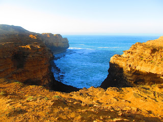
The lookout itself was pretty.  Not as spectacular as some of the views from Phillip Island or along the Great Ocean Road, but pretty.  This was, again, another site of two major shipwrecks.  What I found to be really interesting and unique about this spot was the different flora here compared to PI and GOR.  The bushes were scraggly, and the dirt was hard-packed, dotted with rocks; it was very desert-like. 


Me jumping on the beach at Cape Bridgewater, Australia
From this lookout, we headed back to Cape Bridgewater to park and take a nice walk on Bridgewater Bay Beach.  Caytie and I walked a short ways down the beach, but did a lot of sand writing and shell “shopping.”  I found some shells that had some pre-made holes in the top perfect for a necklace (larger shell) and earrings (smaller shells).  It was a perfect walking beach, with beautiful views, and just about empty so early in the morning!  Caytie did get a great picture of me!

View of the road -- Portland to Adelaide, Australia
From Cape Bridgewater, we headed off along Princes Highway toward Adelaide.  We thought taking the coastal route would be better views than inland.  I don’t know if it was, but I also don’t know if it could have been any worse driving inland!  As we drove along Coorong National Park, it was some of the most boring views ever for the majority of the drive.  The views were either flat fields as far as you could see (which does have a beauty of its own, but not for hours on end) or “scrub” bush (again, its own beauty, just not for hours and hours) that lined either side of the highway.  When the scrub bush broke, however, we got to see some pretty cool dried up salt lake beds.  That was actually the highlight of the whole drive.  Caytie drove, and I played chicken with the scrub brush trying to get pictures of the dried-up lakes!


Dried-up salt lakes along the road between Portland to Adelaide, Australia
Part of why I believe that it was so boring to us is that we had only one other drive that was hours long with so few scenic stops.  That long drive was on our third day from the Blue Mountains to Canberra, and we were still so excited; also, it was twilight, we had seen our first kangaroo, and then it was dark.  This drive from Portland to Adelaide was over six hours, and there were no kangaroos, only dead wombats (I believe), feet in the air.  I expected their eyes to have an “X” over them like in the cartoons!  We actually saw them dead all over Australia, but I think seeing them on this stretch of road added a little excitement.  One last thing that probably didn’t help us on that drive is that the windshield was INUNDATED with bug guts.  It was fairly difficult to see out of the windshield it was so bad.
We stopped in a small town for lunch, and it was really good!  I got a BBQ Chicken Pizza, no capsicum.  What is that, you ask?  Well, I didn’t know either, so Caytie and I asked our waitress.  She said it was a round green vegetable that was sweet.  Okay…still no clue.  The next table over said “You Americans would call it a green pepper.”  Aahhh.  Got it!  It was nice to be out of the car, and lunch was really great.  One of the things on the menu (not the first time we had seen it either) was weinersnitchel.  Who knew that was so big in Australia?!
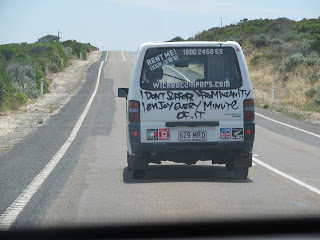
We got back on the road, and got behind the slowest vehicle ever, and it was difficult to pass it because of the curves in the road and the cars coming the opposite way.  I think we were stuck behind the van for about 45 minutes or so.  That might have been part of the “boring” of the drive!  It was, however, a very interesting vehicle.  It was one of the Wicked Campers.  We had seen them everywhere on the road as we drove around Australia.  The vans have some seriously funny sayings on the back of them too!

Well, after passing the Wicked van and getting past the dried up lakes, we finally hit some hills.  This was about 1 hour or so outside of Adelaide.  We arrived in Adelaide and found our hotel.  Ambassadors Hotel was an older building directly downtown and had various classes of rooms from backpacker (which we stayed in) to suites.  The area where our room was located was down some twisty (skinny) halls, and both Caytie and I think that they were probably once servants’ quarters.  The other unique thing about the hotel was the elevator.  It was tiny.  As in any more people than Caytie and I with one suitcase each and you’d have some problems.  Also, there were two doors…one at the front and one to the right (if you’re facing the front).  It was pretty cool. 

I didn’t realize until we arrived in Adelaide, but I had forgotten to check out the parking situation for the hotel when planning our stay there.  We had to park in a ramp, walk to the hotel, check in, and then move our car to the hotel’s “cheaper” parking ramp!  After we got those things done, we called Uchoti (our whole reason for visiting Australia) to let her know we were in town and to make plans for the next day!

We at an early dinner in the hotel.  The dining room was dark woods and marble with some very cool light fixtures.  For dinner, I had a steak and mushroom pie, which was really good. 

After dinner, Caytie and I read and relaxed before heading to bed.

Monday, November 22, 2010

Port Campbell to Portland, Great Ocean Road, Australia

London Bridge
The Arch
Today was a shorter day than we expected, but that turned out well in the end.  We left Port Campbell fairly early in the morning thinking that all the stops we had planned for the day would take far longer than it actually did.  It ended up that all the stops between Port Campbell to Warnambool, where we were stopping to go to Tower Hill (an extinct volcano) only took about 10 minutes each!  So, we headed back out along the Great Ocean Road toward Portland making several stops along the way, hitting several lookouts.  Our final destination was Adelaide, but the majority of people who travel the GOR turn around at Port Campbell (we found out why nobody goes beyond Portland the next day!).  

Our first stop was The Arch. Even though it was very early, the day was already hot and humid (although at the time I thought it was humid, it cannot compare to Cairns!). Because the sun had not quite fully risen over the horizon, it was a beautiful view of the coastline to the west with the bright sun shining gold and orange and highlighting the cliffs’ orange rock and dirt. There was a misty haze over the water that made it look so pretty too!
View of the Grotto from above


Our next stop was London Bridge, which has fallen down (he, he, he).  The bridge fell in 1990, leaving two people stranded on the newly formed island pillar (they were there for several hours before a helicopter rescued them).  It was early enough in the morning that the sun was still leaving a golden light that gave us beautiful views of the rocks and cliffs; again, the mist over the ocean was beautiful.

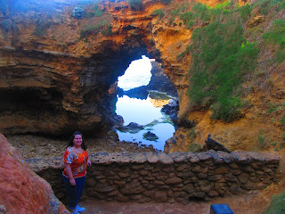
Inside the Grotto cave
Next, we hit the Grotto, a small cave-like area that is being eaten away by the saltwater.  At the top of the cliff, the view was spectacular.  Standing near the edge looking out to the endless ocean and being surrounded by orange cliffs was very soothing so early in the morning.  From the cliff top, it was a few flights of stairs down to the ocean level where the “cave” is located.  It was cool and wet down there, and you could tell that when there was a high tide, the ocean waves crashed into the cave area and drenched it.  It was an interesting point-of-view to look through the hole that has been eroded away by the salt water and to look out to the ocean view.


Our final stop before going to Tower Hill was at the Bay of Martyrs (the site of the 'Falls of Halladale' shipwreck, which hit a reef in 1908 (all survived)) and the Bay of Islands (right next to each other on the walking path) in the Bay of Islands Coastal Park (32km of coastline). 


Again, the views of the coast and beaches were magnificent.  And, like the 12 Apostles, these areas are dotted with limestone pillars and islands that have formed from the erosion of the saltwater along the coast.  There was one particular stack that you could see the foundation being eroded by the waves, which was really cool.

From our final “beach” stop of the day, the road headed inland to Warnambool, where Caytie and I went to the Tower Hill Reserve, a park that has at its center an extinct volcano (last recorded eruption is 6,000 to 7,000 years ago) surrounded by flat marshes and lakes. 


Some of the vegetation was quite interesting.  One tree looked like it had pea pods hanging off of it.  Another tree had these yellowish-white blossoms that were pretty awesome.  We also got to see kangaroos (which never really got old)!  We did also see at Tower Hill one of the most prevalent birds we saw in all Australia (other than the cockatoos in Sydney):  the Australian Magpie, which makes such an unexplainable sound…it woke us at the crack of dawn when we camped in the Snowy Mountains!  Later, as we drove up and out of the “crater,” we also saw (very far away) emus! 
Emus in the field of the "Crater"
Me half way up the Peak Climb
View from the top of the Peak Climb, volcanic rock, and the ocean in the background


We decided to do the Peak Climb, which goes to the top of the tallest hill overlooking the volcano.  It was a brutal climb.  Short, but extremely steep (the pictures do not do it justice), and I was sweating by the time we were a quarter of the way to the top!  I took a few pictures of the crater of the former volcano, as well as the steep hill and the view from the top.  There is a piece of volcanic rock at the top of the hill.  The view was amazing; you could see to the ocean.
On the way up and out of the “crater,” we stopped off to take a picture of the rocks that had formed from the previous eruptions…pretty cool!

It was still morning when we left Tower Hill Reserve, and headed on to Portland.  We drove through a few small towns that had some beautiful, old stone churches. 
We ended up arriving in Portland in the early afternoon, which was great!  We checked into the motel, and headed to town!  We hit the Information Centre, and had lunch at the waterfront in a park.  Afterwards, we headed to the Laundromat.  It was wonderful to be able to relax while we got our cloths washed.  We hit the grocery store next door and resupplied on breakfast and lunch items.  We went back to the motel and vegged out for the evening, having dinner in.

Sunday, November 21, 2010

Melbourne to Port Campbell, Australia, along the Great Ocean Road

Me at the Tweleve Apostles (facing 2 of the 9 that are left)


We were up early, early, early today due to city parking issues and not wanting to pay extra money. After our lovely middle-of-the-night fire drill, and getting up at 5 a.m., we were not exactly ready and raring to go this morning. We had gone to bed fairly early knowing that we were getting up early, so it wasn’t as bad as it could have been. One thing that I DID NOT enjoy was the lack of coffee! It was barely dawn (and mostly dark out) as we were leaving Melbourne, so we figured we’d make it to the Koala Café in plenty of time for breakfast!

The drive to the Koala Cove Café was much longer than originally thought. We got there at 9am…great for breakfast time, not so great for our hungry stomachs! Part of it was our own fault at we made a several stops at overlooks, the Memorial Arch, and two spontaneous hikes (one of which was to a waterfall) along the way. The lookouts were quick stops to take in the view, stretch our legs, and get a few pictures.

The hike down to The Gulch was short and well worth it. It was a short hike down to the beach, but the last little ways was all sand, and down a pretty steep hill. Again, it was well worth it as we had a beautiful, very large stretch of beach pretty much to ourselves! We did some walking, shell collecting, and writing in the sand!


The spot we were at was like a huge cove, with points jutting out to the right and left of us. The point to the right had a lighthouse on it. We gave no thought to the downhill walk in the sand when we were going to the beach, but going back up to the parking lot was pretty funny! The hill is steeper than it looks in the picture. I took it running, got to the top, and took the picture of Caytie trying to trudge her way up it!

The next stop was at the Great Ocean Road Memorial Arch. I’m going to diverge from my trip information, and give a little history of the GOR here. The GOR Trust was set up to raise funds and employ soldiers and sailors returning from WWI (where 64% of those ANZAC soldiers and sailors who had gone to war did not return) to dig out a costal route to link Melbourne and Adelaide, and to provide a beautiful drive to entice tourists to the region. Soldiers started work in August 1918 with surveying the road’s route. However, due to the difficult terrain, by March 1919, only 10 miles had been successfully pegged out. The first charge was detonated on September 19, 1919, and soldiers and sailors went to work with pick and shovel digging a 100-mile coastal road. During the 13-year construction period, nearly 3,000 returned soldiers labored on the GOR. The entire stretch of road from Geelong to Warranbool was completed on April 27, 1932. The GOR is the world’s largest war memorial, as it is dotted with numerous structures that honor the memory of those who lost their lives fighting in WWI and other wars.

OK, history lesson over. :) We stopped at the Arch to read the signs and get a few pictures. We continued on along the road, which hugged the curve of the coast. I pulled over at Cape Patton for another picture (surprise) of the coast. This was an awesome spot for a view of the long coast line.

Our final stop before breakfast was at Carisbrook Falls in the Great Otway National Park, the highest falls along the GOR (although the falls are not vertical, but fall along the rock side and down the mountain into the creek below). The hike was uphill to the falls, which is the kind of hike that I enjoy because then the way back is downhill! The walk was along the side of a hill on a path that had been dug out, following the Carisbrook Creek below. Being extremely hungry by this time, we didn’t linger too long at the falls before we hiked back to our car.

Our next stop was breakfast at the Koala Cove Café in Kennett River. Yummmm is about all I can say. Part of it, I’m sure, is that it was 9am by the time we got there, and I’d not eaten or had any coffee as of yet. But my breakfast (”Brekkie”) sandwich was AWESOME! English muffin, rasher bacon, egg, tomato, and “tomato sauce” equals delish! I was so hungry and it was so good, I think I ate it in about 2 minutes.

After about a half hour, we moved on to our next stop, Mait’s Rest Rainforest Walk. The walk was beautiful! It was mostly a shaded walk, with the sun poking through the canopy every once in a while. It was a fairly easy walk too, and only about 45 minutes long (with stops for pictures). There were very few people around, which was even better. We only came across two other groups on the whole walk!

There were giant ferns, along with Euclyaptus and giant Myrtle Beech trees towering over the ferns! The Myrtle Beech trees are some of the oldest trees in the area. The rainforest is inundated with trees, some of which were being reclaimed by the forest. I was even able to stand under a tree whose roots had (a sign told me) grown around a fallen tree, which then was reclaimed back into the land. It was thoroughly restful and beautiful time. Probably one of the most unique things we did/saw in Australia.
Next we headed to the Cape Otway Lightstation, especially since we were told at one of the Information centers that the drive down to it had tons of Koalas just hanging about in the trees. The drive down to the tip/coast where the lighthouse was at took about 45 minutes. It was a fairly narrow road (not as bad as McKillop’s Road, however) and tree lined. It was gorgeous!

We had planned to go to the lighthouse and take a short walk on the beach, but once we got there, we found out it was going to cost us $16 each to go to the lighthouse, so we passed. The 45 minute trip was not a waste of time, however, because on our way down, we saw some people pulled over to the side of the road with cameras out, pointed at the trees. That’s right, KOALAS! We saw about 20 between the two different stops on our way down, and it was so cool to see them in the wild!

Our next stop on our journey along the Great Ocean Road was at Gibson Steps. We decided not to go down the bazillion steps to the beach, but we went to the overlook and took a few pictures. Because we were so close to The 12 Apostles, we decided to do our walking around there. We didn’t realize, however, that there wasn’t any down-on-the-beach walking, it was all pathways built along the top of the cliffs overlooking the shoreline with views of The 12 Apostles (of which there are only 9 left standing).

The beaches all along the GOR were beautiful, but the ones around The 12 Apostles were especially beautiful and pristine. The 12 Apostles are limestone rocks sticking straight up out of the ocean, and they were awesome. The cliffs and rocks were a gorgeous yellow and the water itself was a beautiful royal and teal blue, depending on where you looked! We looked around, took some photos, and then decided that we had plenty of time to look at the other tourist spots between The 12 Apostles and Port Campbell (our hostel location, about 20 minutes away), and then come back at sunset to get some photos of The 12 Apostles then.

We drove about 500 meters down the GOR to the next parking lot and walked out to the Loch Ard Gorge. The Loch Ard was a ship that wrecked on the cliffs near Port Campbell in 1878 killing all but two of the passengers and crew due to a mist so heavy, they couldn’t see the lighthouse. The two survivors ended up washed up on shore in the gorge. Caytie and I read the signs about the wreck, and then took the stairs down to the beach. It was beautiful! The sand and cliffs were yellow, and the water a beautiful teal. We spent a short while on the beach taking photos and looking at the cave the survivors spent the night in, and then headed back up top.

From that same parking lot, we walked down a path towards Mutton Bird Island and Thunder Cave. We couldn’t get out to view the island because the path was closed off, but we could see it from the main path. Off one of the lookouts, we were also able to see back to the beach where we had stood (Loch Ard Gorge). The cave was similar to the beach in that it was between to juts of cliffs, but there was no sandy beach, only a cave where the water crashed into it making a really loud sound (hence the name, Thunder Cave).

By the end of all these walks (about 2 hours later), my foot was pretty sore. We decided to head on to Port Campbell and check into our hotel for a short rest and to have dinner. We found an extremely small grocery store and got some bread, fruit, and more PB&J. The place we were staying was a backpacker’s hostel. It was a house that had all the bedrooms with multiple bunks, 2 bathrooms, and a kitchen. We had a twin private because we hadn’t wanted to share with anyone, but we could have done one of the bunk rooms with the ocean view and been fine because there was NO ONE else there! It was great! After walking down the main street of the “town” to the grocery store and eating dinner (surprise, surprise…PB&J!), we headed back out to The 12 Apostles.

It was ABSOLUTELY BEAUTIFUL! It was misty out, and the reflection of the sunset in the mist was awesome! I’ll let the pictures speak for themselves!

We stayed to watch the sun go all the way down over the horizon, and we also got to see a beautiful moon rise with the sunset reflecting in the sky!

The ride home was in the dark, and I don’t think I have ever driven through so many bugs in my life! We could barely see out the windshield after the 20 minute drive back to the hostel!

Another beautiful shot of my swollen and purple foot!